


Lot n° 233
Estimation :
200 - 300
EUR
Result with fees
Result
: 515EUR
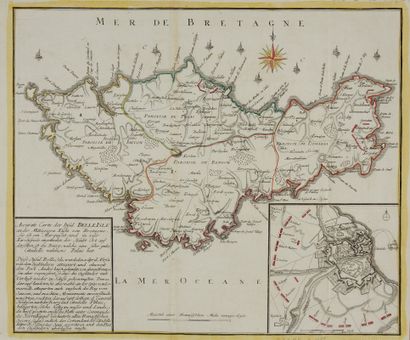
RASPE, G.N. Accurate Carte der Insul Belle Isle. Nuremberg, - Lot 233
RASPE, G.N. Accurate Carte der Insul Belle Isle. Nuremberg, ca. 1765. Boundaries in old col. Traces of folding. A fine copy with the boundaries and compass rose coloured at the time. 215 x 355 mm.
Rare map of Belle-Île divided into parishes. In cardboard, a map of the citadel of Le Palais. The German text under the title relates the attack and capture of Belle-Île by the English between April 1761 and June 7, 1761. The French military commander of the island, the Chevalier Sainte Croix, surrendered on June 8, after more than a month of siege of the Palais. "The Capture of Belle-Île-en-Mer" is the name given to the British expedition in which the French island of Belle-Île-en-Mer, located off the coast of Brittany, was captured in 1761, during the Seven Years' War. After an initial British attack was repulsed, a second attempt led by General Studholme Hodgson allowed British troops to land. A second landing subsequently took place and, after a six-week siege, the island's main citadel at the Palace was removed, sealing British control over the island."
My orders
Sale information
Sales conditions
Return to catalogue